Paradise in the Desert
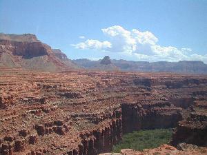
One
of the most breathtaking sights in northern
This
is where our
adventure onto the lands of the Hualapai
and Havasupai Indians begins. From I-40,
exit at either Seligman or Kingman (depending on which direction you
are coming
from) to the two-lane old U.S. Route 66 (a fun trip in itself) for
about 1-2
hours to the town of
While checking in, we were offered free ear plugs. This seemed odd until we realized that a double set of mainline railroad tracks ran right behind the lodge with trains passing at least every 20 minutes blowing their whistle for the nearby crossing. Apparently, there are a lot of people who don’t like train sounds but that didn’t bother us, because we are also train fans!
After a good meal in the restaurant, we did some shopping in the gift shop and bought some locally made items at very reasonable prices. There was also live entertainment in the lobby provided by some Tribal members who were singing and dancing while dressed in traditional tribal garb. We listened and watched for a little while before deciding it was time to call it a night so we could get a good night’s rest.
An
early start
was needed and we were up and out of bed by
4:30 a.m. This was enough time to gather
our gear, check out of the hotel and start the one hour drive to the
Hilltop
parking lot. Not far from the lodge we
turned onto Indian Highway 18, a narrow paved road running 68 miles
north off
of Route 66. There are no services on
this long and winding road and it is the only paved road to the
parking
lot at Hualapai Hilltop. We ate a
nutritious breakfast of food bars and fruit while we rode in the car. The road was still very dark and it took two
sets of eyes to watch for cattle or other animals that might wander
into the
roadway. We didn’t want to start the day
with road kill!
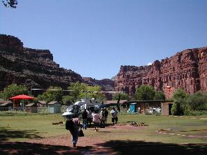
There
was not
much to see upon reaching the parking lot
other than pack horse sheds and the helicopter pad.
Unless you’ve made arrangements for a short
helicopter ride to the village or rented a horse to take you down the
trails,
you should have your backpack and camping gear ready for an 8 mile hike
to
This
hike is
considered to be moderately difficult. Heck,
after last year’s rim to rim hike
across the 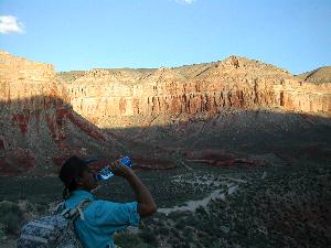
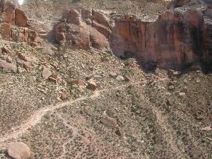
The
sun was not
quite full on us as we hiked on the Hualapai
Trail through
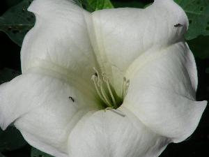
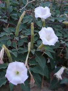 The
Sacred
Datura
plant, with its beautiful white trumpet-shaped flowers, was everywhere. Soon the trail joined with the Topocoba Trail
coming out of
The
Sacred
Datura
plant, with its beautiful white trumpet-shaped flowers, was everywhere. Soon the trail joined with the Topocoba Trail
coming out of
By
the time we
reached Havasu Creek, a tributary to the
The
red walls of
the canyon were soon towering high above us
and we got our first look at the Wii'igliva (pronounced wig-leeva),
a
Havasupai god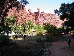 and goddess that watch over and protect the village.
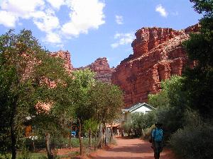
We followed the trail into populated areas
near ranch houses where small plots of ground were marked off for
gardens or
horse sheds. Occasionally, we saw a
horse grazing in a corn patch. Makeshift
fences had been erected along the trail to keep people from wandering
onto
personal property and most of the buildings and homes were small,
simple structures.
and goddess that watch over and protect the village.
We followed the trail into populated areas
near ranch houses where small plots of ground were marked off for
gardens or
horse sheds. Occasionally, we saw a
horse grazing in a corn patch. Makeshift
fences had been erected along the trail to keep people from wandering
onto
personal property and most of the buildings and homes were small,
simple structures.
As
we made our
way into the village, the trail evolved into
the main road of the village where many of the Havasupai went about
their work
on ATVs and small tractors. Our first
stop was the tourist office where we checked-in for the campground,
picked up
our permit, and took a short rest. I
checked my watch. We made the 8 mile
hike in four hours. Not bad!
We inquired about renting horses to ride out
in a couple of days and, although renting two horses was fairly
reasonable, we
would have to hire an extra horse for our backpacks.
Then we were told that for ten dollars more
per person we could take the helicopter and there was no extra charge
for our
backpacks. Now that sounded like a good
idea! We’ll keep that in mind too!
 This
was the
heart of the village. Looking
around, we
saw the helicopter pad,
the café, the grocery store, the post office, and the school. The post office in
This
was the
heart of the village. Looking
around, we
saw the helicopter pad,
the café, the grocery store, the post office, and the school. The post office in
As
we hiked, we
could hear the sounds of Jamaican music
coming from several houses and small farms.
It struck us as odd to hear Jamaican music on an Indian
Reservation. The sights and sounds of
the village quickly fell behind us as we headed for the campground. A group of pack horses passed us with a few
dogs trailing behind. Most of the
residents we saw, silently watched us pass. We
were told the flash flood that swept
through Havasu Creek the previous week washed out a few of the trails. A couple of workers doing trail repairs
advised
us how to pick our way through. We heard
the sound of water and thought it was just the creek rushing nearby,
not
realizing that we just missed the side trail to 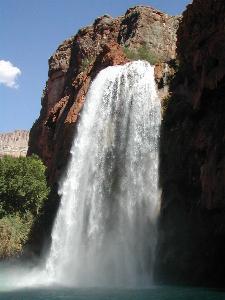 way out.
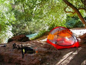
After searching the camping area to find an area that was dry and level, we found a good spot to pitch our tent that was near a picnic table and under a tree. A rope hanging from the tree was useful in hanging our food bag. We put our water bottles into a mesh bag and tied it to a tree root at the edge of the creek. While tossing the bag into the creek, I slipped between the roots of the tree and ended up hip-deep in the cold creek. That was unexpectedly refreshing! After the hiking and setting up camp, we were pretty tired and decided to rest through the hottest part of the day.
In
the middle of
the afternoon, we grabbed a snack and a
couple of water bottles and hiked back to the trail leading down to the
shore
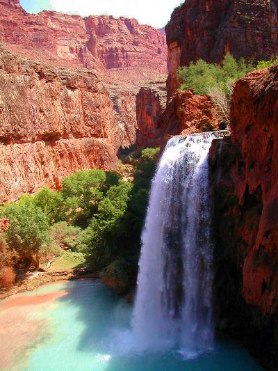
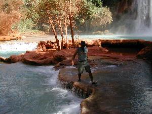
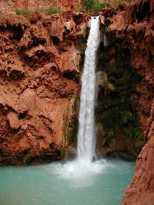
at the base of the falls. It was
amazing! There was quite a bit of shade on the large pool but the water
fall
was still in the sunlight as it continued to thunder its way 100 feet
down into
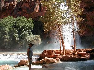
the travertine pools below. After putting
our things down in a dry spot, we waded into the cold water making sure
to stay
in the lighter areas. The darker areas
of the pools meant deeper water. We swam
a little and then went back to shore to get our cameras before making a
precarious balancing-type walk across the tops of the pools. The ledges were narrow and slippery but we
wanted to explore the mini-falls where the water drops down to the next
lower
level into the creek. The sun was clear
of the canyon walls and there wouldn’t be much daylight left. We headed back to camp to make some dinner
and prepare the campsite for the night.
The canyon walls tend to hold the heat for a long time after sunset. The night itself was uneventful, but we were hot. At one point, we were both stripped down to our underwear. In the hours just before dawn, the air finally got cool and we would wake up intermittently and put a piece of clothing back on. By dawn, we were fully dressed again!
 A
large group was
camped at the edge of the creek when we
arrived and this morning they were packed up and heading out as we were
exiting
our tent and moving about. While having
our breakfast of peanut butter and jelly on tortillas, we were overcome
with
“campsite envy.” We were on high ground,
but a large area next to the creek was now available.
There were only a few other groups in the
campground, but we couldn’t wait much longer if we were going to make a
move. We discussed it for about 5 more
minutes before picking up our tent and carrying it over to the new spot. We looked like a couple of cats moving in
circles trying to find the “perfect” spot to settle in.
Should we be close to the big rock? Which
way should the tent opening face? We even
inherited a lounge chair and a couple
of
A
large group was
camped at the edge of the creek when we
arrived and this morning they were packed up and heading out as we were
exiting
our tent and moving about. While having
our breakfast of peanut butter and jelly on tortillas, we were overcome
with
“campsite envy.” We were on high ground,
but a large area next to the creek was now available.
There were only a few other groups in the
campground, but we couldn’t wait much longer if we were going to make a
move. We discussed it for about 5 more
minutes before picking up our tent and carrying it over to the new spot. We looked like a couple of cats moving in
circles trying to find the “perfect” spot to settle in.
Should we be close to the big rock? Which
way should the tent opening face? We even
inherited a lounge chair and a couple
of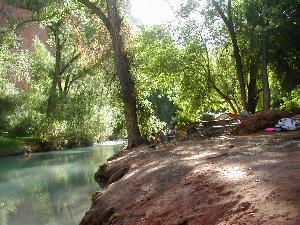 inflatable pool toys from the former tenants. Cool!
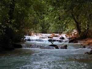
The
hike was easy
and the trail meandered alongside of the
creek. Before we knew it, we came upon
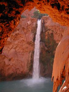
the falls from the top. The water was
cascading almost 200 feet to the large pool below and the travertine
“drapes”
on the walls were lush and green with ferns and vines growing out of
them. The trail continued down a couple of
short
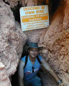
switchbacks and we were trying to figure out how to get down to the
bottom when
we turned and saw the tunnel with a sign to “descend at your own risk.” OK . . . since it looked like that was the only
way to get down, we ducked our heads and headed down the steps notched
into the
travertine.
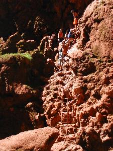
When
we got to
the other end of the short vertical tunnel,
we poked our heads into the sunlight and looked almost straight down at
a
series of chains, footholds and handholds on the outside of the
travertine
drapes. We would still have to manage that
before we would touch the sandy ground again.
This is no place to be if you have an unconquerable fear of
heights! Looking straight out, you have
a great view of the falls as if to provide incentive to make the climb
down. At this point, you turn your body
to face the cliff wall and hold onto the chains that are staked to the
wall as
you climb down. The last section was on
an aluminum ladder that was precariously anchored to the wall. Finally, we were at the bottom!
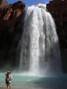
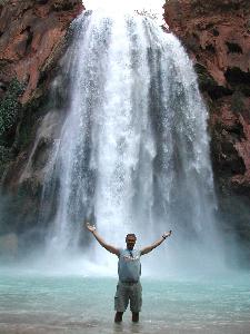
As we turned to take in our surroundings, we
gasped at the magnificence of the falls.
Standing at the edge of the pool at the base of the falls, we
were
awestruck! We decided we were going to
spend the majority of the day here and, luckily, we had some snacks,
fruit and
water to sustain us while we swam and played.
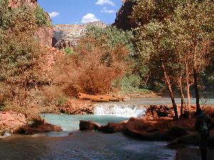
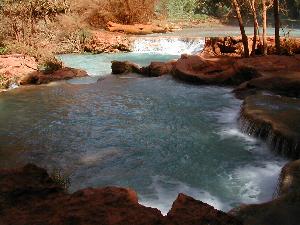
We
had a blast while at these falls! We found
a rope swing, lots of pools to swim
in and several more travertine ledges making mini-falls as the water
continued
through the creek on its way to the last waterfall.
Upon
returning to
our campsite, we were met by a stray dog
who seemed content hanging out with us.
Mike napped on top of the picnic table and “Buddy” napped under
the
table. Meanwhile, I took some photos
before
trying to get some rest in the tent.
Our canine friend, Buddy, met us back in camp and became our protector. Some other dogs came sniffing around while we were eating and he growled and barked at them to run them off. Of course, he was rewarded with our leftovers. When we went into the tent for the night, Buddy laid down near the tent opening. Sometime during the night, he went off to investigate a noise and commotion elsewhere in the campground and we didn’t see any more of him. The weather during the night was windy as if a storm was brewing nearby. The trees swayed in the wind and it cooled off pretty quick, but it didn’t rain.
The morning dawned clear and bright. I had been nursing a cold and woke up with a heavy chest, so we decided to pack up our gear early and hike into the village so we could have breakfast at the café and check into taking the helicopter out. Once again, we could hear the sounds of Jamaican music in the air. On reaching the heart of the village, we were able to put our names on the list for the helicopter and went to the café. The food was good and the helpings were big. We’d been missing our morning coffee and were enjoying the first cup we’d had in a few days.
We have a nice conversation with a tribal member at the café while we were waiting for breakfast. He told us about the Gathering of the Pai’s Festival (pai meaning ‘the people’) that is held every year between the five tribes and the Peach Festival held there in the village each year. We just missed the Peach Festival by a few days. He talked about the visit of Bob Marley’s son, Ziggy Marley, to the village many years ago and how Bob Marley’s music is still very popular with the people. That explained why we heard so much reggae music as we walked through the village. The man told us that in the “old days” they used to get movies and show them outdoors on the side of a building. The actors, like John Wayne & Clint Eastwood, would become heroes to the people who would pretend to be the characters.
We
will return to
Supai and the land of the blue-green
waters in order to visit
Helpful Links:
Havasupai Tribe - http://www.havasupaitribe.com/home.html to Aggressive
Home to Travels,
Hobbies & Interests
to Aggressive
Home to Travels,
Hobbies & Interests